Mr. Tredinnick's Class Site
  • Home
  • Geography Courses
    • AP GIS&T
    • AP Human Geography
    • Biogeography >
      • Biogeography Forum
    • Cartography
    • Ecological Biogeography >
      • Ecological Biogeography Forum
    • GEOG 1020 - Human Geography
    • GEOG 1030 - Physical Geography
    • GEOG 4100/8106 - Biogeography
    • GEOG 8040 - Seminar in Geography Education
    • Geographic Information Systems (GIS)
    • Global Studies >
      • Global Studies Forum
    • Human Geography (Rubenstein)
    • Human Geography (Tredinnick)
    • International Relations: World Environmentalism Focus >
      • International Relations: World Environmentalism Forum
    • World Geography
  • History Courses
    • AP European History >
      • AP Euro Forum
      • AP European History 2013-2014
    • AP World History
    • Art History
    • Minnesota History
    • United States History
    • World History (Fall Semester)
    • World History (Spring Semester)
    • World History Summer Session
  • Political Science Courses
    • AP Comparative Government >
      • AP Comparative Government Forum
    • AP U.S. Government >
      • AP U.S. Government Forum
    • Environmental Policy >
      • Environmental Policy Forum
    • International Relations
    • U.S. Government >
      • US Government Forum
  • Elective Courses
    • Behavioral Science >
      • Behavioral Science Forum
      • Social Science >
        • Social Science Forum
    • Economics
    • Psychology >
      • Psychology Forum
    • Sociology >
      • Sociology Forum
    • Zoo Operations: Conservation Geography
  • About

Forum Sem1a - Establishing Knowledge on Watersheds

9/16/2022

5 Comments

 
National Oceanographic and Atmospheric Administration Office of Water Prediction, https://water.noaa.gov/map 

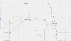
Using the National Oceanographic and Atmospheric Administration’s Office of Water Prediction map students should identify the closest stream to your own home. Once you have found that, you should use the map to try and trace the route that water from that stream would take all the way to a sea, ocean, or gulf. (For example: Elkhorn River into Platte River, into the Missouri River, to the Mississippi River, to the Gulf of Mexico
). For more information on watersheds, drainage basins, and how water moves through streams use the Watersheds and Drainage Basins website (https://www.usgs.gov/special-topics/water-science-school/science/watersheds-and-drainage-basins) put together as part of the Water Science School of the USGS.


Once you have completed your downstream trace, you will group up with other students who had the same closest stream and check each other’s work to ensure you all came up with the same pathway. 

Once all groups are complete, we will work as a full group to discuss the following questions
  1. Describe the route that water from your own community takes once it moves downstream. 
  2. Predict: Why is this type of information important to know when trying to understand stream health and water quality?
Lesson Objectives:
  • Students can identify the closest stream  in their community and its downstream locations. 
  • ​​​Students can describe the process through which trash and other pollutants can have a negative impact on stream health
  • Students can explain the degree to which  conservation efforts can have on impacting stream health.

Picture
5 Comments
Bea
10/24/2022 07:56:18 am

-Elmwood Creek to the Papillion Creek to the Missouri River to the Mississippi River to the Gulf of Mexico
-water from places across the world's land will almost always end up in the ocean
-polluting a local water source will pollute all the water sources that it feeds
-your pollution can ruin the water of people down stream

Reply
Ella J
10/24/2022 07:58:02 am

The water in my community ends up connecting to papio creeks and then to the Missouri, then the Mississippi River which goes to the Gulf of Mexico. The things we let get into the water near us can get all the way throughout the water systems it connects to.

Reply
sims
10/24/2022 07:58:08 am

hell creek - goes to the missouri
it’s important to know where it goes because even if it’s a small little bit of water pollution can pollute a bigger water source

Reply
ella h
10/24/2022 08:40:54 am

- fricke creek
starts at hickory hill park, goes to papillion creek then to missouri river
- because if one creek gets contaminated then the other bigger water sources get contaminated

Reply
stella
10/24/2022 12:44:14 pm

-elm wood creek
-papillon creek
-Missouri river
-mississippi river
-gulf of mexico

Know that what you do still impacts the ocean!

Reply


Leave a Reply.

    Environmental Policy Class Forum

    Welcome to the Forum! Here is where you will be answering your daily warm-up questions. Please do not enter your last name for privacy reasons, and you may use a nickname if you would like (Just make sure Mr. Tredinnick is aware of the nickname you are using). Write out thoughtful responses to the forums on the days they are assigned. If you miss a day please take it upon yourself to complete the Forum you missed. Each Forum has the targeted Learning Objective(s) there so you can see what the focus of the day's class will be.

    Archives

    November 2022
    October 2022
    September 2022
    December 2020
    November 2020
    October 2020
    June 2020
    September 2019
    August 2019
    May 2019
    April 2019
    December 2017
    November 2017
    October 2017
    September 2017
    August 2017

    Categories

    All
    Unit I Forums
    Unit Summative Discussion

    RSS Feed

Powered by Create your own unique website with customizable templates.